| Pages
| ||
|
Mill Creek Flood Jan-Feb 2017 Nature does not say "I'm sorry."
Mill Creek Flood 2017 | |||
|
The previous year, WeatherMen predicted "Godzilla El Nino," blah, blah. Compared to the hype the winter was a dud. For 2016-17 there was no prediction of anything out of the ordinary. What we experienced was a succession of "atmospheric rivers," one after another, lasting for months. The precipitation total was highest in California recorded history. | |||
|
"Water pepper-eating bugs eat it willingly"
Is this what I wanted when I bought this land? - - While holding a cold, or a hot drink, looking out on picture-postcard pastoral harmony - trim, suburban grass; happy, chuckling waters? My family would be far more pleased by that. But that role I just can't wear. | ||
|
162 _17Jan14-nmf_1242  |
136 _17Feb12-nmf_1801  |
133 _17Feb12-nmf_1248  |
|
Location of the site; Footbrige and typical camera locations
| ||
|
193 _51101NashMillRd Yellow lines bracket the footbridge location. This satellite view is five years old. The ravine would look different now.  |
194 _FootbridgeAndCameras Most pictures are shot from the bridge deck or from beneath the bridge as indicated by the camera icons.  |
|
|
Peace reigned for years prior to 2017. There is always a lot of water in the winter. It passess harmlessly under the brige, thanks to my channel improvements of 2007-2011.
| ||
|
117 _11Feb20-nm_1117a Placid in 2011. This is the high water of this season. The boulder is the datum which appears consistently for five years.  |
119 _12Jan26-nm_1630 Placid in 2012 at peak water time.  |
119 _12Mar17-nm_1017b Placid in 2012 Note the datum boulder at center left.  |
|
120 _16Jan16-nmPLUS_1058 2016 Placid in 2016 This is high water time. 2016 saw pretty heavy rain for a few weeks, "Godzilla El Nino." No problem in the creek. Note the datum boulder.  |
121 _16Jan23-nmPLUS_1159 In 2016 at nearly peak water. Note the white-barked alders. The following year they become villians.  |
125 _16Mar12-nm_1148a 2016, March. The owner should have dealt with those alders but did not perceive an urgency.  |
|
View downstream from the footbridge after the first battle of the 2017 Demon War
| ||
|
155 _17Jan14-nmf_1124b This is nearly the same view as those above.  |
124 _16Mar12-nm_1146a Here is the same view, a year ago (to refresh your memory.)  |
171 _17Jan28-nmf_1211 A week later The white-bark alders spanning the creek are the same as those appearing in 16Mar12, above. As one great assembly they have rotated and moved slightly downstream. The catastrophic consequence of this scenario is obvious in hindsight.  |
|
157 _17Jan14-nmf_1159a View of the debris mountain from ground level.  |
||
|
For years, the creek flowed past peacefully. By widening the channel successively over five years I relieved the violence of winter floods. Until 2017.
| ||
|
120 _12Mar29-nm_1019 Placid in 2012 though this is nearly peak water.  |
122 _16Jan23-nmPLUS_1159b The north end bridge piers, nearly at water level, was always the concern after it was washed out in 1/1/2006.  |
125 _16Mar12-nm_1148  |
|
Demon mischief, the like I never imagined. The place is nearly unrecognizable.
| ||
|
156 _17Jan14-nmf_1128a The whole ravine is full of downed debris. Beneath, the creek is raging. The scene is hard to understand.  |
157 _17Jan14-nmf_1158  |
155 _17Jan14-nmf_1127  |
|
167 _17Jan28-nmf_1140a  |
||
|
The flood deposited a great willow cluster directly beneath the bridge in mid-channel. The current is being thrown to both sides of the clump, more to the north than to the south. I wondered how long the north end piers could withstand this exceptional onslaught.
| ||
|
152 _17Jan14-nmf_1123  |
||
|
Beginning Jan 14 I crawl out onto the clump to try to lighten it a little and to cut the root network connecting it to other clumps.
| ||
|
162 _17Jan14-nmf_1242 |
159 _17Jan14-nmf_1213b  |
174 _17Jan28-nmf_1218 All I can do under these conditions is try to disconnect the root nodes from each other in hopes they can wash away.  |
|
149 _17Feb25-nmf_1303 View from my perch on the debris island, preferably viewed in a TV commercial in a dry, warm room.  |
||
|
The successive floods have continued. Small stuff has washed away. The great clump has moved a little, allowing a clearer view.
| ||
|
127 _17Feb04-nmf_1032 Weeks later the view is cleaner. The offending object has moved downstream slightly. Its form is clear. These huge willow clusters were torn from the bank upstream and floated them downstream, foliage first.  |
172 _17Jan28-nmf_1217 The floating clumps engaged with the great barricade, growing it.  |
|
|
The stream has scoured away some of the debris deposited over preceding weeks, concentrating and reinforcing it into one mighty barrier just downstream of the bridge.
| ||
|
146 _17Feb25-nmf_1017 The debris on the bank I had cleared. It's easier to reach the creek.  |
147 _17Feb25-nmf_1020 These guys remain connected. I want them disconnected.  |
149 _17Feb25-nmf_1256 The debris island split the flow. This is the straight-line branch, the course formerly followed by the creek. It is no longer favored by the creek, and will shortly after go dry.  |
|
The bridge survived successive "atmospheric river" onslaughts. By Feb 12 the creek had done the impossible, changing its course sideways by ten feet.
| ||
|
129 _17Feb12-nmf_1059 The creat clump has moved slightly downstream. There it fused with the great debris island formed a month earlier.  |
129 _17Feb12-nmf_1110 Same view, from opposite shore.  |
129 _17Feb12-nmf_1101a The lessons I took from the 1/1/2006 flood included nothing about this.  |
|
130 _17Feb12-nmf_1111 The battering-ram current was turned 90 degrees by the interlocked debris mountain, aiming it directly toward the south side bank, easily swallowing it. The bank proved to be a pile of sand.  |
130 _17Feb12-nmf_1110b This was the result.  |
137 _17Feb25-nmf_1012 A week later. A lot more of the soft south bank has dissolved. Is the other pier O.K.?  |
|
137 _17Feb25-nmf_1012a The flood has carried away even more bank, creating a deep, boiling pool directly under the pier. Along this line downstream, vast volumes of dirt have washed downstream to sea.  |
151 _17Feb25-nmf_1326a View down the floating pier. There is nothing below which can support a temporary brace.  |
139 _17Feb25-nmf_1012c By Feb 25 the floods have cleared the debris which was not locked into the structure.  |
|
131 _17Feb12-nmf_1114 I crossed to see if the bridge could still support our weight. One person at a time, clinging with two hands to the handrail, it is possible but unsafe.  |
129 _17Feb12-nmf_1101 Walking across this, on a deck with a film of wet moss, is pushing our luck.  |
|
|
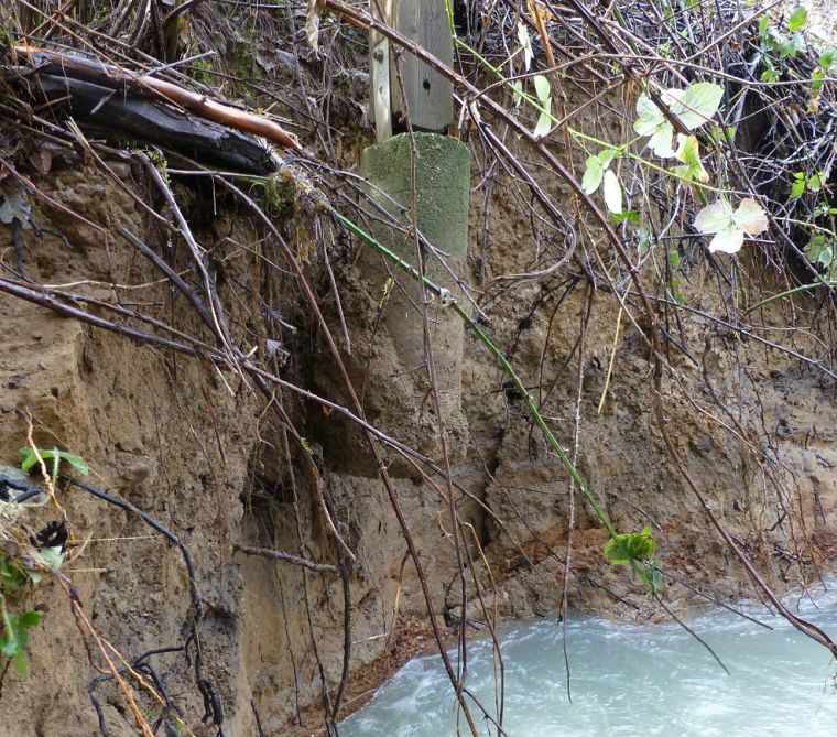
The north end piers, object of my worry for ten years, were unperturbed.
| ||
|
140 _17Feb25-nmf_1012d  |
149 _17Feb25-nmf_1254 The elaborate precautions I applied - concrete, bracing, "vegetative hard points" - did their job.  |
|
|
Seventy feet upstream I notice a couple of huge logs. I could not say whether they were there before.
| ||
|
170 _17Jan28-nmf_1152b I rarely visit this spot. Maybe it was formerly inaccessible due to willow growth. On Jan 28 I noticed these huge logs.  |
168 _17Jan28-nmf_1151 Boss does not perceive the peril.  |
|
|
I now recognize huge torpedos the demons have stowed. Released to float downstream these could have founded another great heap of debris or snapped a bridge pier. One was bobbing in the stream, ready to launch.
| ||
|
134 _17Feb12-nmf_1742 Feb 12, the situation has turned urgent. The torpedo is about to launch. This log has to get hauled higher onto the bank. It is waterlogged. I can barely rock it by foot.  |
135 _17Feb12-nmf_1742a This is not how I planned to spend this short winter day.  |
148 _17Feb25-nmf_1025 Cable and "come-along" are the only way to move it. I almost snapped the redwood to which I attached the cable.  |
|
141 _17Feb25-nmf_1014 After two successive Saturdays of hauling the log up the bank, it clears the water by what seems an adequate amount.  |
144 _17Feb25-nmf_1016 I guess I'm now O.K. for this winter.  |
|
|
Debris hanging from tree limbs indicates the water was at least this high
| ||
|
175 _17Jan28-nmf_1219  |
||
|
This is where the great willow clumps were wrenched from the bank.
As I watched the precipitation numbers rise higher through Janurary, I wondered what would occur at this spot. What actually happened took me by surprise. I believe the creek channel was long ago tortured into an "S." Over decades the creek plans to straighten out. | ||
|
131 _17Feb12-nmf_1119a For at least ten years I had observed at this location an impenetrable thicket of willow. If forced humans who tried to walk up the creek to make a wide berthy.  |
145 _17Feb25-nmf_1016a  |
170 _17Jan28-nmf_1152a The gouge on the left is the void seen from upstream.  |